
Mapping & Information Management
Inlailawatash has a strong reputation for mapping and information management. We provide a range of Geographic Information Systems (GIS) services, technical support, and analysis to both external and internal partners. While we serve a wide variety of clients, we understand—and have extensive experience meeting—the unique needs of indigenous governments and organizations.
We Offer
Mapping Services
Cartography (bioregional and inventory atlases, land use mapping)
Use and occupancy mapping (base mapping, digitization, final maps, transcript spatialization)
Archaeology mapping support (AIAs, AOAs, archaeology potential modeling, least cost analysis)
Referral mapping and analysis support
Online mapping tools
Drone imagery and mapping
Data collection (digitization, direct-to-digital, field-based GPS surveys)
Research and acquisition (historical maps, documents and air photos)
GIS training, assessment and strategy development
Mapping systems, data warehouse, hardware and software setup


Featured Projects
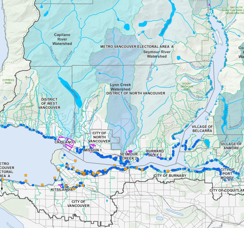
Water Quality Assessment and Proposed Objectives for Burrard Inlet
One of our team members, Allison Hunt, has worked closely with Tsleil-Waututh Nation to put together a series of Water Quality Objective Maps which were completed in February 2020. These maps included data from 29 sources, all of which were in different formats, attribution categories, and methodologies. We were able to consolidate this data into clean datasets and to represent all the information together accurately.
The proposed objectives can be viewed here.

Burrard Inlet Drone Kelp Survey
During the summer of 2020, Inlailawatash assisted in the maping of kelp extent along an eight-kilometer section of shoreline in Vancouver Harbor and Burrard Inlet.
A drone was used to collect high-resolution orthomosaics which was combined with ground observations and image classification techniques to interpret the extent of kelp coverage within the project area.
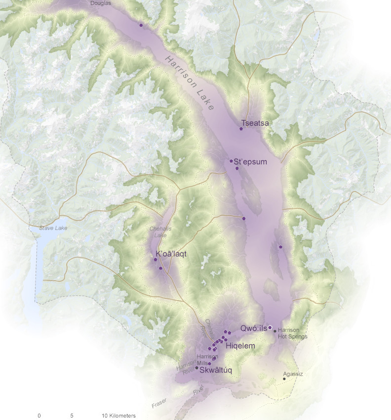
Sts’ailes Xa’xa Temexw Bioregional Atlas
Inlailawatash assisted Sts’ailes in the development of a comprehensive bioregional atlas for Sts’ailes “Xa’xa Temexw”. The intent of the atlas was to assist in outlining the high level land use framework/strategy for the entire Harrison Watershed, articulating the critical biophysical features, areas of concern, and culturally sensitive areas pertaining to the Sts’ailes traditional land use histories and current negotiated rights and title status. A total of 22 maps were created for the atlas, which will be used by Sts’ailes to assist in negotiations, economic development, public education, future planning and cultural protection.

Sugar Cane Archaeology Mapping Support
Sugar Cane Archaeology is a wholly owned First Nations company based out of Williams Lake. Inlailawatash provides Sugar Cane with various types of mapping services to support their heritage management and natural resource stewardship services.
GIS Clients
Birds Canada -- Dr. Alan McMillan -- Firelight Group -- First Nations Technology Council -- Fisheries and Oceans Canada -- Fort McKay First Nation -- Gwawaenuk Tribe -- High Bar First Nation -- Integral Ecology Group -- Komoks First Nation -- Kwikwetlem First Nation -- Kwusen Research -- Lower Fraser Fisheries Alliance -- Métis Nation British Columbia -- Northern Shuswap Tribal Council -- Penticton Indian Band -- Reciprosity Research -- Soda Creek Indian Band -- Stikeman Elliot -- Sts'ailes First Nation -- Stswecem'c Xgat'tem First Nation -- T'Sou-ke First Nation -- Tsleil-Waututh Nation -- Sugar Cane Archaeology -- Wild Bird Trust of British Columbia -- Williams Lake First Nation -- Wolf and Crow
Services: Mapping: Essentials
We have discovered and generated extensive information that we believe mappers working in aboriginal communities should be aware of—and take full advantage of. These resources include tools, and links to training, conferences and community forums.
![]()
GIS Mapping is more than a service. It provides an opportunity to build capacity within the organizations we work with—through access to training, resources and data—that empowers them to accurately survey and record their territory and achieve their long-term objectives.